Beinn Ime’s Height: 1011m
Summit Grid Reference: NN 255 084
Translation: Small Butter Hill
Start Point: From Loch Long Car Park, Inveruglas or Glen Croe
Beinn Ime: An Essential Guide to Scotland’s Popular Munro
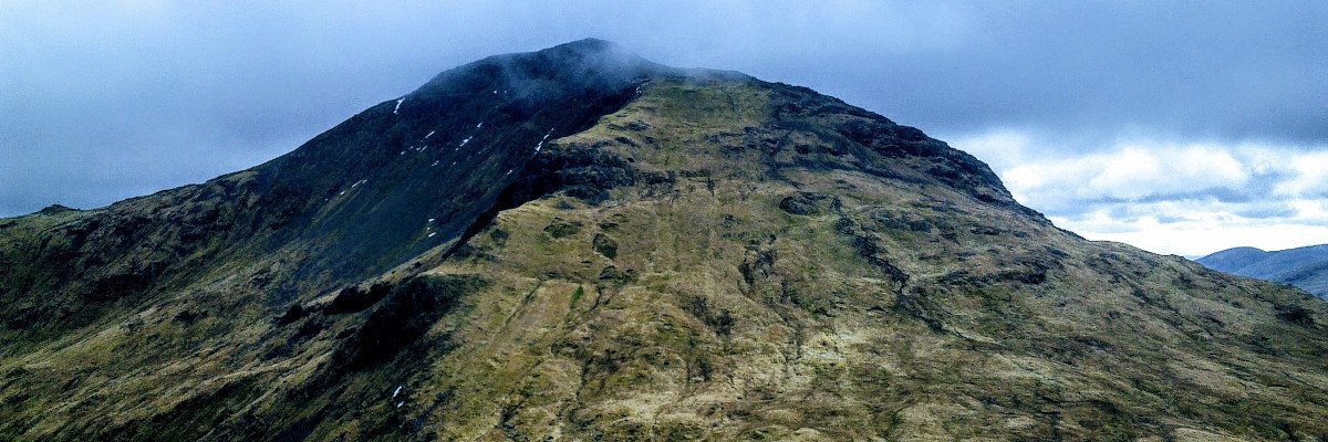
Beinn Ìme is a majestic mountain located in the Arrochar Alps of Argyll, in the Southern Highlands of Scotland. Known for being the highest peak within this range, Beinn Ìme sits proudly at an elevation of 1,011 metres. The mountain, which is referred to as a Munro (a Scottish term for mountains above 3,000 feet), boasts a richly diverse landscape and is often praised for its awe-inspiring scenery. The name Beinn Ìme comes from the Scottish Gaelic term for ‘butter mountain’, which is a fitting description for the smooth and rolling slopes it possesses.
Hikers exploring Beinn Ìme can embark on several different routes depending on their preferences and skill levels. The most common ascent follows the broad southern slopes from the Bealach a’ Mhàim, while other sides of the mountain are known for being much steeper and more rugged. As part of Loch Lomond and The Trossachs National Park, the area also provides opportunities for nature-lovers to encounter a variety of flora and fauna. With its combination of dramatic topography, challenging terrain, and captivating beauty, Beinn Ìme offers a truly unforgettable experience for those who venture to conquer its heights.
Beinn Ime Overview
Location
Beinn Ime is located within the Arrochar Alps, an expanse of mountains west of Loch Lomond, in Scotland. It is situated amidst the Loch Lomond & The Trossachs National Park, making it a prominent and popular destination for hikers and nature enthusiasts alike.
Elevation
Standing at an impressive 1,011 metres, Beinn Ime is the highest peak in the Arrochar Alps. Its conical peak and craggy landscape create an awe-inspiring backdrop for those looking to explore the surrounding area.
Designation
Beinn Ime holds the title of a Munro, which is a classification given to Scottish mountains over 3,000 feet (914.4 metres) high. This distinction attracts experienced hikers and mountaineers to the area who aim to summit the various Munro peaks throughout Scotland.
Climbing Beinn Ime
Beinn Ime, standing at 1,011 metres, is the highest peak in the Arrochar Alps located within Loch Lomond & The Trossachs National Park. The mountain offers impressive views of the nearby peaks and the Cowal Peninsula, making it a popular destination for hikers and climbers. In this section, we will explore the different climbing routes, difficulty levels, and the average time required for climbing Beinn Ime.
Routes
There are various routes available, both for rock and winter climbing on Beinn Ime:
Rock Climbing:
- Ben’s Fault (120m)
- Airy Ridge (100m)
- Buttress Route (120m)
Winter Climbing:
- Fan Gully (100m)
- Hanging Groove (170m)
- Forked Gully (150m)
Rock climbing on Beinn Ime is concentrated on the east face, primarily on Fan Gully Buttress.
Difficulty Level
The difficulty level of climbing Beinn Ime is subjective and depends on individual physical capabilities and confidence. In general, some rock climbing routes can be challenging, especially for beginners, but the mountain is accessible to experienced climbers.
- Beginner: For beginners, ascending the broad southern slopes from the Bealach a’Mhàim is often recommended.
- Intermediate to Advanced: Experienced climbers can attempt the east face routes, especially the technical rock climbing routes.
Average Time Required
The time required to climb Beinn Ime depends on the chosen route, experience level, and weather conditions. However, on average, the ascent and descent can take between 6-8 hours, including breaks. Proper planning, gear, and checking weather forecasts are essential before starting the climb.
Flora and Fauna
Vegetation
Beinn Ìme, being part of the Arrochar Alps, has a diverse range of vegetation that spans across its altitude. At lower elevations, the vegetation primarily comprises deciduous and coniferous woodlands. As the altitude increases, the dense forests give way to heather, grasses and sedges, commonly found on the upper slopes of the surrounding Scottish Highlands.
Mosses and lichens can also be observed on rocky surfaces and alongside watercourses that run throughout the mountain, adding a unique aspect to the overall plant life in the area.
Wildlife
The mountainous terrain of Beinn Ìme provides an ideal habitat for various wildlife species, both common and unique to the region. Red deer can often be spotted grazing on the slopes, while the elusive mountain hare can be found at higher altitudes, camouflaging themselves perfectly in the heathery landscape.
Birdlife is also abundant in the area, with birds of prey such as golden eagles and red kites being observed soaring above the peaks, providing an impressive sight for hikers and wildlife enthusiasts. The intricate ecosystem around Beinn Ìme also supports numerous smaller bird species like meadow pipits, skylarks and even occasional sightings of the striking ptarmigan, a species particularly adapted to the Scottish Highlands environment.
In terms of smaller fauna, the delicately balanced ecosystem also hosts a range of insects and butterflies, which in turn, form an essential part of the food chain for the mountain’s bird and mammal populations.
Safety and Preparation
Before you set out for a hike on Beinn Ime, it’s essential to be well-prepared and aware of potential hazards. In this section, we cover important safety aspects for your trek, including weather conditions and emergency procedures.
Weather Conditions
Mountain weather can be unpredictable, particularly in the Scottish Highlands. Make certain to check the forecast before heading out for a hike on Beinn Ime. Prospective hikers should especially watch for incoming storms, heavy rain, and high winds, as these conditions can lead to slippery paths, poor visibility, and increased risk of accidents.
A useful tool for monitoring mountain weather in the UK is the Mountain Weather Information Service (MWIS). This website provides accurate and detailed forecasts for various regions, including the Scottish Highlands.
Emergency Procedure
In case of an emergency on Beinn Ime or the surrounding area, hikers should be prepared to respond effectively. Remember that mobile network coverage might be unreliable in the mountains. Here are some steps to follow during an emergency:
- Dial 999 or 112: In the UK, either of these numbers will connect you to emergency services. Be sure to provide them with accurate information on your location and the nature of the emergency.
- Use the international emergency signal: If a phone is not available, use the international emergency signal, which consists of six long whistle blasts or torch flashes, followed by a one-minute pause, and then repeated until help arrives.
- Carry a map and compass: Familiarise yourself with your route’s map and compass before you begin your hike to ensure that you’re capable of navigating in case of an emergency.
Preparation is crucial for a safe and enjoyable experience on Beinn Ime. Therefore, pay attention to the given advice and be well-equipped for any circumstances that might arise during your hike.